
Sale!

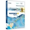
GARMIN Navionics+ US007R U.S. East Electronic Chart
Original price was: $149.99.$93.99Current price is: $93.99.
- We take quality seriously.
- 7-Day Returns, 100% Quality
- High quality products, low prices.
- 7 days free returns

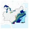
Detailed coverage of the lakes, rivers and coasts of Connecticut, Delaware, Illinois, Indiana, Kentucky, Maine, Maryland, Massachusetts, Michigan, New Hampshire, New Jersey, New York, North Carolina, Ohio, Pennsylvania, Rhode Island, South Carolina, Tennessee, Vermont, Virginia and West Virginia.
Features:
- Integrated Garmin and Navionics® content, with an updated color palette and Navionics style appearance, provides exceptional coverage, clarity and detail
- Easy access to daily chart updates is available via the ActiveCaptain® app
- Built-in Auto Guidance+™ technology uses your desired depth and overhead clearance, along with chart data and frequently traveled routes, to calculate a suggested path to follow from dock to dock (Auto Guidance is for planning purposes only and does not replace safe navigation operations.)
- NOAA raster cartography is available as a free downloadable feature via the ActiveCaptain® app and can be displayed on your mobile device or compatible chartplotter
- Depth range shading lets you select up to 10 color-shaded options and view your target depths at a glance
- For improved fishing and navigation, up to 1’ contours provide a more detailed depiction of bottom structure
- To aid in navigation, the shallow water shading feature highlights depths up to a user-defined level
- ActiveCaptain® community content provides valuable POIs, recommendations and advice from boaters with firsthand experience of the local environment
- Worldwide coverage available
- Available on microSD™ cards or via download (each region sold separately); cartography updates are available via annual renewable subscription (the first year of updates is included)
- This product is intended for use in compatible Garmin chartplotters only.
| Card Type | Garmin Navionics+ |
|---|---|
| Cartography | U.S. East |
| Type | Electronic Charts |
Be the first to review “GARMIN Navionics+ US007R U.S. East Electronic Chart”
Related products
Sale!

Original price was: $379.99.$95.99Current price is: $95.99.
Sale!


Original price was: $453.00.$96.99Current price is: $96.99.
Sale!
Original price was: $69.99.$46.89Current price is: $46.89.
Sale!
Original price was: $449.99.$96.99Current price is: $96.99.
Sale!

Original price was: $149.99.$93.99Current price is: $93.99.
Sale!
Original price was: $159.99.$93.99Current price is: $93.99.
Sale!

Original price was: $466.00.$96.99Current price is: $96.99.
Sale!

Original price was: $89.99.$59.39Current price is: $59.39.
Reviews
There are no reviews yet.